Dash Cam GPS Viewer: See Your Route and Speed on a Map
Dash cams with GPS record where the car was every second, inside the video file. Here's how to see that route on a map coloured by speed, save it as GPX, KML, CSV or an image, and why some clips show no route at all.
A dash cam with GPS writes the car's position into the video, usually once a second, so the clip itself knows where it was recorded, how far the car went and how fast. You don't need the manufacturer's desktop player to see it: drop the original MP4 or MOV into our Dash Cam GPS Extractor and the drive appears on a map, coloured by speed, with the distance, the duration and the times. From there you can download the route as GPX, KML or CSV, or save the map as a picture.
It's handy after a near miss or an accident, for an insurance claim, to log business trips, or just to see where a scenic drive took you. This guide shows what the viewer tells you, how to read the speed colours, which file to download for which app, and what to check before you post dash cam footage online.
How to view a dash cam's GPS route online
- Copy the original video off the memory card. Take the file exactly as the camera saved it. Clips exported from a phone app or trimmed in an editor often lose the GPS.
- Open the Dash Cam GPS Extractor and drop the video in. It takes MP4 and MOV files up to 100 MB. If your clips are larger, set the dash cam to record 1-minute clips (most models offer 1, 3 and 5 minutes).
- Read the route. If the video carries GPS, you get the drive on a map in a few seconds, with download buttons underneath.
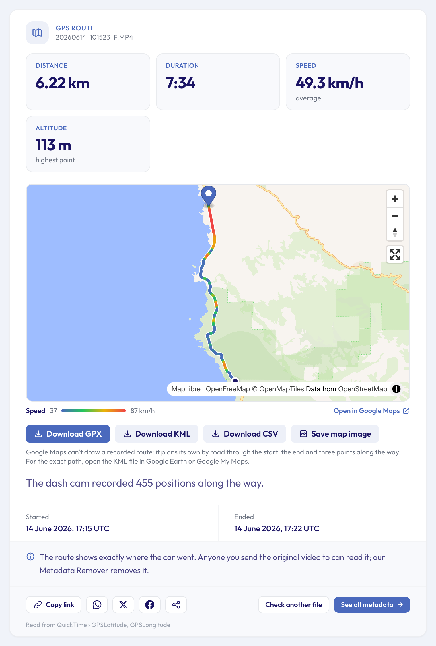 An example drive south on Highway 1 over Bixby Bridge: the blue stretches are the slow bends, the red ones the straights.
What the route viewer shows
- Distance: the length of the drive, measured along every recorded position, not in a straight line.
- Duration: from the first position to the last, which usually matches the clip's length.
- Average speed: the distance divided by the time.
- Altitude: the highest point, when the camera records height.
- The map: the whole route, from the pin where recording started to the dot where it stopped. Zoom and pan freely; Show whole route brings the full drive back into view.
- Started and Ended: the date and time of the first and last positions, in UTC, straight from the satellites. That's often more trustworthy than the dash cam's own clock, which many people never set. For the clip's own recording date, the Video Date Checker reads it from the file.
Reading the speed from the colours
The line changes colour with the speed at each point: blue for the slowest stretches, then green, yellow and red for the fastest. The scale under the map gives the range for this clip, so blue on a motorway clip can mean 80 km/h, while on a city clip it can mean walking pace.
A few things to know about these speeds:
- They come from the GPS positions, worked out from the distance between two positions and the time between them, then smoothed over a few seconds so that GPS jitter doesn't make the line flicker.
- The scale skips the extremes. It runs from the slowest to the fastest speeds the car really held, so one glitchy position can't wash out every colour.
- GPS speed isn't your speedometer. It's usually close, and often more honest than the speedometer, but tunnels, tall buildings and steep valleys can make positions jump. Treat a single red blip with suspicion; a long red stretch is real.
Save the route: GPX, KML, CSV or an image
Every format holds the same route, for different uses:
| Download | What it is | Open it in |
|---|---|---|
| GPX | The standard GPS track: every position with its height and time | Most mapping, navigation and fitness apps, Google Earth |
| KML | The path as a line, for Google's map tools | Google Earth, Google My Maps |
| CSV | A spreadsheet: latitude, longitude, altitude and time, one row per position | Excel, Google Sheets, Numbers |
| Map image | A PNG of the map as you've framed it, with the coloured route and the speed scale | Anywhere a picture goes: email, reports, chats |
The image saves exactly what you see, so zoom in on a junction first if that's the part that matters, or press Show whole route to get all of it.
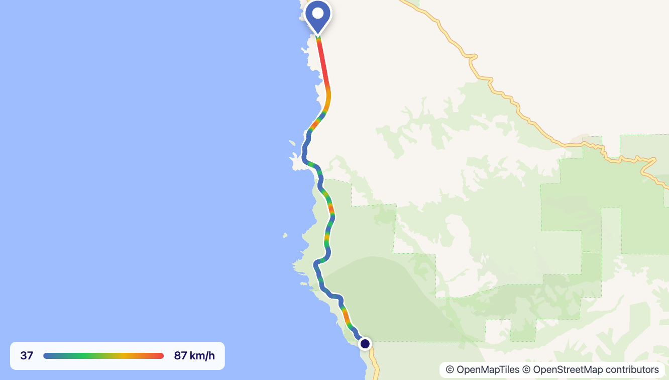 The PNG from "Save map image": ready to attach to an email or a claim form.
Can you see a dash cam route in Google Maps?
Partly. A Google Maps link can hold a start, an end and a few stops, but not a recorded track, so Open in Google Maps gives you directions through the start, the end and three points along the way. Google then plans its own route along the roads, which matches a normal car journey closely but not a detour, a car park or a U-turn.
For the exact path in Google's tools, use the KML file:
- Google Earth: open the KML file and the route appears as a line over the satellite view.
- Google My Maps: create a map, choose Import and pick the KML file. You can then share that map with anyone.
Every GPS position, second by second
The route card shows the summary. For the raw data, press See all metadata under the result: the full metadata of the video includes a GPS Track section that lists every position the camera recorded, with its coordinates, altitude and time.
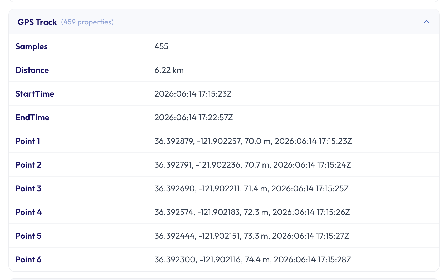 One row per second: the same data as the CSV download, readable in the browser.
The same full view has everything else the file holds, from the recording date to the codec and the frame rate.
Which dash cams record GPS in the video
Most dash cams with a built-in or plug-in GPS receiver save the positions inside each video file, once a second, along with the time and often the speed. Each brand uses its own layout; the tool reads the common ones, from models by Garmin, Nextbase, Viofo, BlackVue and Thinkware to the many dash cams built on Novatek chips.
A few work differently:
- GPS in a separate file. Some cameras keep the track in a
.gpsor.nmeafile next to the videos. The tool reads the GPS inside the video, so those clips show no route. - GoPro and other action cameras. They record GPS too, in their own format, often several times a second. Our GoPro GPS Extractor reads those.
- Phones. A phone usually saves one position, where recording started, rather than a track. The Video Location Finder shows it on a map.
Why no route is found
If the tool finds no route, it's usually one of these:
- The camera has no GPS, or the GPS module was unplugged. Many dash cams sell it as an add-on that clips onto the mount.
- GPS was switched off in the camera's settings, or the receiver hadn't found any satellites yet. The first minute after starting the car, or a clip recorded in a garage, can have no fix.
- The file isn't the original. Videos exported from the dash cam's phone app, trimmed, joined or compressed usually come out without the GPS.
- The camera keeps GPS in a separate file, as described above.
Dash cam GPS after an accident or for an insurance claim
The route, the times and the speed help you show where and when something happened, and how fast you were going in the seconds before. A few habits make that evidence stronger:
- Keep the original files from the card, untouched. Copy them off before the camera loops over them; many dash cams overwrite the oldest clips when the card fills up. Lock the clip on the camera if it has an emergency button.
- Share copies, not your only original. The downloads and the map image are copies you can attach to a claim; the original video stays the source.
- Check the date too. The Video Date Checker shows when the clip was recorded, and the GPS times give a second, satellite-based clock to compare it with.
Before you post dash cam footage online
A dash cam route is one of the most revealing things a video can carry. Most drives start or end at home or at work, and the GPS in the file shows both to within a few metres, along with the time you left. Anyone who gets the original file can see it: by email, through a cloud link, or on a site that keeps uploaded files as they are.
If you're sharing a clip of a near miss or a scenic road, make a clean copy first with the Metadata Remover: it takes the GPS track and the other hidden details out of the video and leaves the picture and sound as they are.
FAQ
How do I see the GPS data on my dash cam footage without the manufacturer's software?
Drop the original video into the Dash Cam GPS Extractor. It reads the positions the camera saved inside the file and shows them on a map in your browser, with no player to install.
How do I convert dash cam GPS to GPX?
Upload the clip and press Download GPX under the map. The file holds every recorded position with its time and, when the camera saved it, its height.
Can I see how fast I was driving at a given moment?
Yes. The colour of the line shows the speed along the whole route, with the scale under the map. For exact figures, download the CSV: every row has the time and position, one per second, so the speed between any two rows is the distance divided by the time.
Does it work with GoPro videos?
GoPro cameras store GPS in their own format; use the GoPro GPS Extractor, which works the same way and gives the same map and downloads.
Why does the route start a little away from where I parked?
A GPS receiver needs a moment to find enough satellites. The first positions after starting the car can be missing or a few metres off, so the route may begin a little down the road.
Does removing the GPS change the video?
No. The Metadata Remover copies the picture and sound streams as they are and leaves out the GPS track and the other hidden details, so the clean copy looks and sounds exactly like the original.
See your dash cam route now
Got a clip and want to know where it was recorded and how fast you were going? Open the Dash Cam GPS Extractor, drop in the original video from the card, and see the drive on the map in seconds. For anything else your files can tell you, the free metadata tools each answer one question, and the metadata viewer shows everything at once.